Recently, Researcher He Xianqiang and his collaborators published a research paper entitled Development of the operational atmospheric correction algorithm for the COCTS2 onboard the Chinese new-generation ocean color satellite in the international optics journal Optics Express. The first author is Bai Ruofeng, a joint-training doctoral student co-supervised by our laboratory and Shanghai Jiao Tong University, and Researcher He Xianqiang serves as the corresponding author. Co-authors include Researcher Ye Xiaomin, Researcher Ma Chaofei and Researcher Song Qingjun from the National Satellite Ocean Application Service, Associate Researcher Li Hao from the East China Sea Laboratory, as well as Researcher Bai Yan, Associate Researcher Jin Xuchen, Engineer Zhang Xuan and Senior Engineer Gong Fang from our institute.
China launched its new-generation ocean color satellite HY-1E (also referred to as HY-3A) in November 2023, marking the upgrade of China’s ocean color satellite system to the second-generation technical framework and greatly enhancing the real-time monitoring capability for global marine ecological resources, marine environment and ocean disasters.
One of the core payloads carried by HY-1E is the second-generation Chinese Ocean Color and Temperature Scanner (COCTS2). It is equipped with newly-added short-wave infrared observation bands for the first time, enabling full-spectrum ocean color observation covering ultraviolet to short-wave infrared bands and effectively improving the applicability of satellite data under diverse water body conditions.
Given the low reflectance of water bodies, nearly 90% of the total radiance received by satellites originates from interference signals such as atmospheric scattering and water surface reflection, while genuine water-leaving radiance only accounts for about 10% of the total received signals. Therefore, accurately eliminating atmospheric scattering and water surface reflected radiance from satellite observations to extract effective water-leaving radiance is one of the core key technologies for the processing and application of ocean color satellite remote sensing data, which is universally defined as atmospheric correction.
The development of high-precision atmospheric correction algorithms relies on coupled ocean-atmosphere vector radiative transfer models. Previously, Researcher He Xianqiang independently developed the PCOART model, which fully takes into account the Earth’s curvature, rough sea surface and radiation polarization effects, and has served as the core model for atmospheric correction processing of China’s series of ocean color satellite data.
In this study, precise scattering lookup tables, aerosol scattering lookup tables and atmospheric diffuse transmittance lookup tables tailored for COCTS2 were generated based on the PCOART model, and an operational high-precision atmospheric correction algorithm applicable to COCTS2 remote sensing data was established accordingly.
With the constructed atmospheric correction algorithm, on-orbit radiometric calibration for ultraviolet and visible bands of COCTS2 was further carried out using global water body remote sensing reflectance products from SNPP/VIIRS as reference. It was found that the radiometric calibration coefficients of COCTS2 vary with scan angles. To solve this problem, this study established a scan-angle-dependent radiometric calibration coefficient model, which effectively addresses the radiometric response discrepancy of the COCTS2 payload at different scan angles.
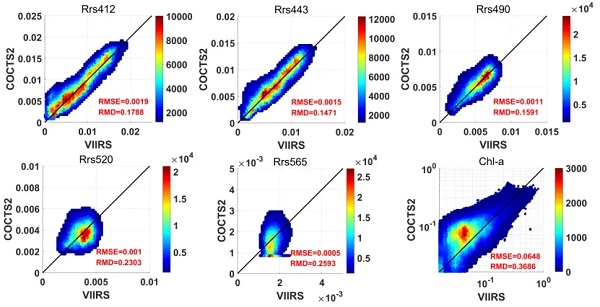
Furthermore, this study compared the remote sensing product quality derived from COCTS2 with that of mainstream international ocean color satellites. The results show favorable overall consistency, verifying that remote sensing products generated by the proposed operational atmospheric correction algorithm possess high stability and accuracy.
The atmospheric correction algorithm established in this research has been officially applied to the operational processing system of HY-1E/COCTS2 satellite observation data, providing important technical support for the production and popularized application of HY-1E/COCTS2 remote sensing products.
Fig.1 Variation trends and corresponding fitting functions of radiometric calibration coefficients for the first 11 bands of COCTS2 with scan angles (pixels). The red line represents the overall average calibration coefficient.
Fig.2 Comparison between water body remote sensing reflectance retrieved by COCTS2 and in-situ measured values at sea. (a)(b) Verification results based on field observations in the East China Sea; (a) results after scan angle correction, (b) results without scan angle correction. (c)(d) Verification results based on field observations in the South China Sea; (c) results after scan angle correction, (d) results without scan angle correction.
Fig.3 Comparison of global remote sensing products (water-leaving reflectance Rrs of each band and chlorophyll-a concentration Chl-a) derived from HY-1E/COCTS2 and SNPP/VIIRS on October 10, 2024.
Fig.4 Global monthly average ocean color remote sensing products (water-leaving reflectance Rrs of each band and chlorophyll-a concentration Chl-a) retrieved from HY-1E/COCTS2 in March 2025.
Citation
Ruofeng Bai, Xianqiang He, Xiaomin Ye, Hao Li, Yan Bai, Chaofei Ma, Qingjun Song, Xuchen Jin, Xuan Zhang, and Fang Gong, "Development of the operational atmospheric correction algorithm for the COCTS2 onboard the Chinese new-generation ocean color satellite," Optics Express 33, 38029-38053 (2025).
Related References
[1] He, X., Stamnes, K., Bai, Y., Li, W., & Wang, D. (2018). Effects of Earth curvature on atmospheric correction for ocean color remote sensing. Remote Sensing of Environment, 209, 118–133.
[2] He, X., Bai, Y., Zhu, Q., & Gong, F. (2010). A vector radiative transfer model of coupled ocean–atmosphere system using matrix-operator method for rough sea-surface. Journal of Quantitative Spectroscopy & Radiative Transfer, 111(10), 1426–1448.