Recently, researcher HE Xianqiang and his collaborators from our laboratory published a paper titled "Intelligent Atmospheric Correction Algorithm for Polarization Ocean Color Satellite Measurements Over the Open Ocean" in the well-known journal IEEE Transactions on Geoscience and Remote Sensing in the field of remote sensing. Research paper on intelligent atmospheric correction algorithm for remote sensing. The first authors of the paper are researcher HE Xianqiang of our laboratory and PAN Tianfeng, a doctoral student jointly trained by our laboratory and Zhejiang University. The corresponding author is researcher HE Xianqiang. The collaborators include researcher BAI Yan of our laboratory, researcher WANG Difeng, associate researcher LI Teng, and senior engineer GONG Fang, and Professor Palanisamy Shanmugam of IIT Madras.
Ocean color satellite remote sensing uses optical sensors to observe the upward spectral radiation signal at the top of the atmosphere. After atmospheric correction, the water-leaving radiation information is obtained, and then the concentration or component information of different substances in the water is inverted. Traditional ocean color satellites only detect the radiation intensity signal (the first element in the radiation Stokes vector [I, Q, U, V]). With the development of satellite sensor technology, ocean color satellite detection is developing from radiation intensity to Stokes vector detection (for example, NASA plans to launch the PACE satellite in 2024), which is expected to detect water-leaving radiation vector signals. Due to the complex radiation transfer process of the ocean-atmosphere coupled medium system and the weak polarization information of water-leaving radiation (large interference from the atmosphere and water surface), as well as the various application requirements of polarized ocean color remote sensing, atmospheric correction of satellite measured vector radiation is crucial.
To address this problem, this paper further proposes an intelligent polarization atmospheric correction algorithm (IPAC) based on the previously proposed PACNIR algorithm (Pan, He*, et al., 2023). This algorithm can effectively process multi-angle, multi-spectral and polarization satellite observation data, and extract information on the polarization component of water-leaving radiation, as well as aerosol characteristics (coarse mode and fine mode) of the open ocean and intrinsic optical parameters of the water body.

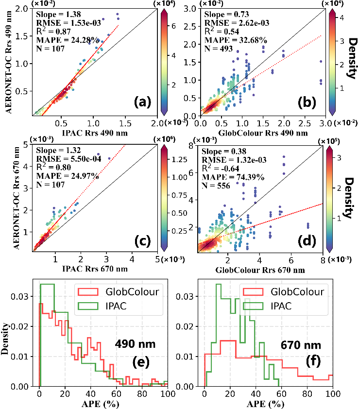
Figure 2 Comparison of the IPAC algorithm inversion results, GlobColour ocean color remote sensing products and AERONET-OC observation data. (a) and (c) IPAC results, (b) and (d) GlobColour data, (e) and (f) relative error probability density function.


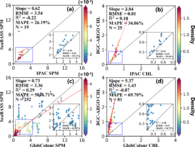
Figure 5 Verification results of suspended particulate matter concentration (SPM) [unit: g m-3] and CHL [unit: mg m-3] in PARASOL/IPAC and GlobColour products based on field measurement data in 2011. (a) IPAC/SPM, (b) IPAC/CHL, (c) GlobColour/SPM, (d) GlobColour/CHL. The insets in (a-d) are from their blue box regions: 0.50≤SPM≤4.5 g m-3, 0.10≤CHL≤0.90 mg m-3.
Citation:
X. He *, T. Pan, Y. Bai, P. Shanmugam, D. Wang, T. Li, and F. Gong, "Intelligent Atmospheric Correction Algorithm for Polarization Ocean Color Satellite Measurements Over the Open Ocean," IEEE T Geosci Remote. 62, 1-22 (2024).


