Progress in automatic identification technology in HE Xianqiang's team
Time:2023-07-06 21:03:00 Views:Author:hyyg
Recently, the team of researcher HE Xianqiang and his collaborators in our office published a research paper titled "Monitoring and spatial traceability of river water quality using Sentinel-2 satellite images" in the TOP journal Science of The Total Environment (citation 1). The first author of the paper is ZHANG Kueyin, a doctoral student jointly trained by our laboratory and Zhejiang University. The corresponding author is researcher HE Xianqiang. The collaborators include researcher BAI Yan, senior engineer Gong Fang, researcher WANG Difeng, senior engineer Zhu Qiankunzheng, and deputy director LI Teng. Researchers, senior engineers LIAN Gangzheng, senior engineer ZHANG Zili, and engineer YANG Ying of the Zhejiang Provincial Ecological Environment Monitoring Center, and Dr. JIN Xuchen of the Southern Marine Science and Engineering Guangdong Laboratory (Guangzhou).
Not only are there a large number of small and medium-sized coastal rivers that enter the sea, but they also have a relatively developed basin economy and relatively high nutrient concentration in the water. Therefore, their discharge into the sea has an important impact on offshore water quality and biogeochemical cycles. The spatial scale of small and medium-sized rivers entering the sea is relatively small. The existing special water color satellites with high radiation sensitivity have a spatial resolution of hundreds of meters or kilometers. It is difficult to effectively monitor the water quality of small and medium-sized rivers. Land satellites with high spatial resolution need to be used. monitor. Since Landsat satellites usually have low radiation sensitivity, few wavebands, and large channel bandwidths, it is difficult to accurately extract water spectra. In addition, the material sources and components of water bodies in small and medium-sized coastal rivers are complex, and it is difficult to obtain high-precision inversion of water body elements, especially biochemical parameters such as nutrients and salts that have no direct optical absorption or scattering effects.
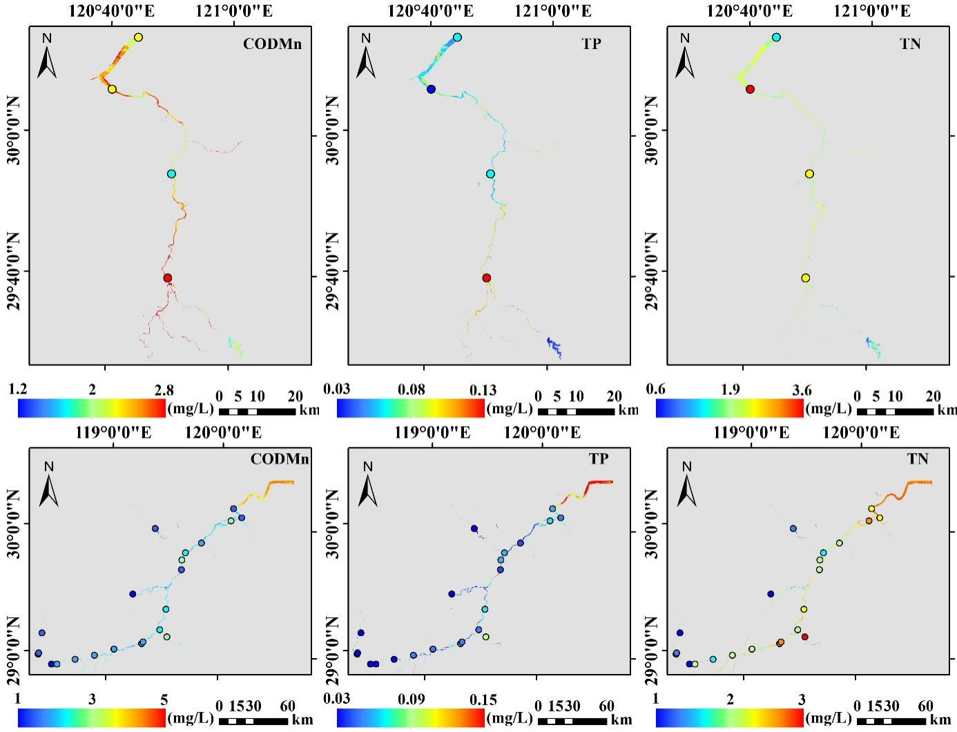
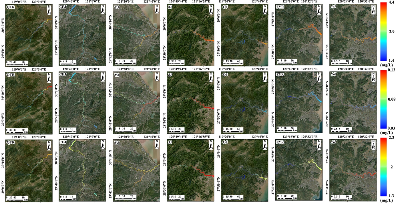
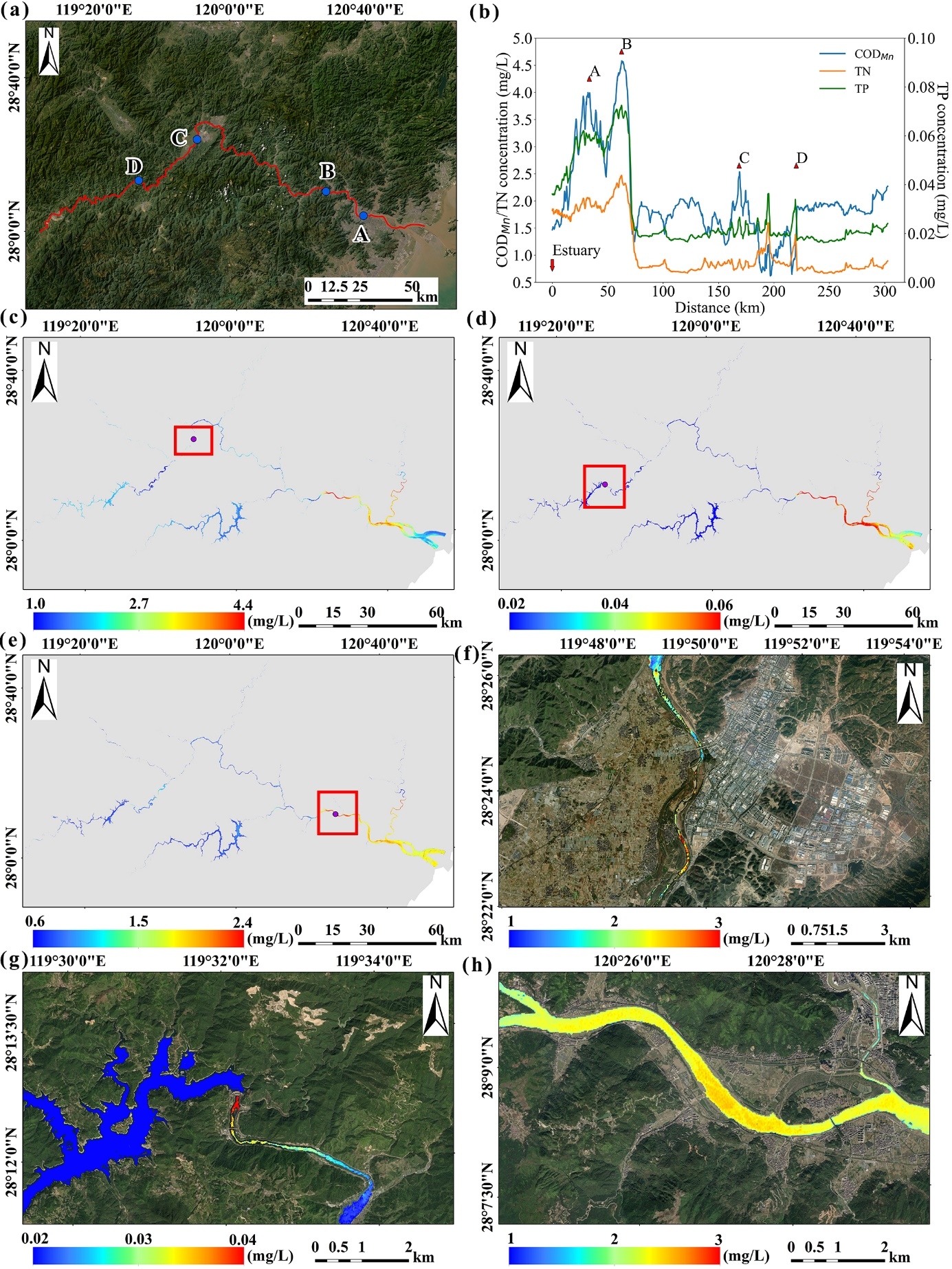
This study takes the seven main rivers that enter the sea in the Zhejiang Province (the Qiantang River, the Cao'e River, the Yongjiang River, the Jiaojiang River, the Oujiang River, the Feiyun River, and the Aojiang River) as examples, and implements remote sensing monitoring of water quality of small and medium-sized rivers and remote sensing traceability of water pollutants based on Sentinel-2 satellite data. The research has conquered the atmospheric correction technology of high spatial resolution satellite data, and constructed a remote sensing inversion model of total nitrogen, total phosphorus, and permanganate index. Verification shows that there is good consistency in spatial distribution and magnitude between water quality parameters retrieved by remote sensing and results from ground measurement sites (Figure 1). Based on the constructed remote sensing algorithm model, this study further obtained remote sensing products of water quality parameters of seven rivers entering the sea in Zhejiang Province from 2016 to 2021 (Figure 2). Based on large-area simultaneous observations of satellite remote sensing, the location of relatively highly polluted areas can be accurately identified. Figure 3 shows the results of the Oujiang River on September 20, 2022. The remote sensing results can be used to track the changes in nutrient concentration along the river from the estuary to the upper reaches (Figure 3b). It can be seen that the three water quality parameters show similar change trends along the way, reaching a peak at 62.5km from the river mouth (point B), then declining sharply to about 74.3km, and then fluctuating to a low value to 300km. By tracking along the route, the locations of relatively high pollution areas (local peaks) can be obtained, such as point A (33.4km), point C (168.6km) and point D (220.2km) in Figure 3b, and can be obtained by further local zoom-in. The fine spatial distribution of water quality parameters (Figure 3f-3h) and analysis of their possible causes can provide important information for precise river pollution control.

Figure 1 Comparison of the spatial distribution trends of water quality parameters (permanganate index CODMn, total phosphorus TP and total nitrogen TN) between satellite inversion and site measured (circles). The upper row shows the Cao'e River results on November 9, 2021, and the lower row shows the Qiantang River results on January 3, 2022.

Figure 2 Spatial distribution of the average values of permanganate index (top), total phosphorus (middle) and total nitrogen (bottom) from 2016 to 2021

Figure 3 (a) The line along the main trunk of the Oujiang River; (b) The change curve of each water quality parameter from the estuary to the upper reaches (satellite monitoring results on September 20, 2022); (c)-(e) are respectively Spatial distribution of permanganate index, total phosphorus and total nitrogen retrieved by satellite; (f) Spatial distribution details of permanganate index at point C (red box in Figure 3c); (g) Total total at point D Details of the spatial distribution of phosphorus (red box in Figure 3 d); (h) details of the spatial distribution of total nitrogen at point B (red box in Figure 3 e).
This study is a new result obtained by He Xianqiang's team after recently conquering the remote sensing automatic identification technology of color anomalies in the sea drainage outlet (citation 2). The relevant technology has been commercially applied to the remote sensing monitoring of coastal water quality in the Zhejiang Province.
Citation:
[1] Yingyin Zhang, Xianqiang He*, Gang Lian, Yan Bai, Ying Yang, Fang Gong, Difeng Wang, Zili Zhang, Teng Li, Xuchen Jin. Monitoring and spatial traceability of river water quality using Sentinel-2 satellite images. Science of The Total Environment, 894, 164862, 2023.
[2] Yuxin Wang, Xianqiang He*, Yan Bai, Yingyu Tan, Bozhong Zhu, Difeng Wang, Mengyuan Ou, Fang Gong, Qiankun Zhu, Haiqing Huang. Automatic detection of suspected sewage discharge from coastal outfalls based on Sentinel-2 imagery. Science of The Total Environment, 853, 158374, 2022.


