Recently, HU Qiwei, a doctoral candidate jointly trained by our office and Shanghai Jiao Tong University, published a paper titled "Reconstruction of 3-D Ocean Chlorophyll a Structure in the Northern Indian Ocean Using Satellite and BGC-Argo" in the international journal IEEE Transactions on Geoscience and Remote Sensing. Data "'s research paper, the collaborators include Dr. CHEN Xiaoyan, Researcher BAI Yan, Researcher HE Xianqiang, Dr. LI Teng and Researcher PAN Delu from our office.
Phytoplankton chlorophyll a concentration (Chlorophyll a, Chla) is commonly used to characterize phytoplankton biomass. However, the chlorophyll a concentration obtained by satellite can only represent about one-fifth of the total phytoplankton biomass content in the euphotic layer, and cannot reflect the changes in phytoplankton biomass below the sea surface, especially in the subsurface chlorophyll maximum layer (Subsurface layer). Chlorophyll Maximum Layer (SCML) tropical ocean. Therefore, effectively obtaining the vertical distribution characteristics of chlorophyll a concentration is of great significance for scientific assessment of phytoplankton biomass and in-depth understanding of ocean carbon sinks. The growth of phytoplankton is mainly controlled by light and nutrients. For the northern Indian Ocean, the supply of nutrients is affected by physical processes such as monsoon-driven reversal currents, upwelling, and vertical migration of the thermocline. Therefore, by establishing the relationship between Chla and the physical parameters of the water column profile, it is possible to obtain the distribution characteristics of Chla within the entire euphotic depth.
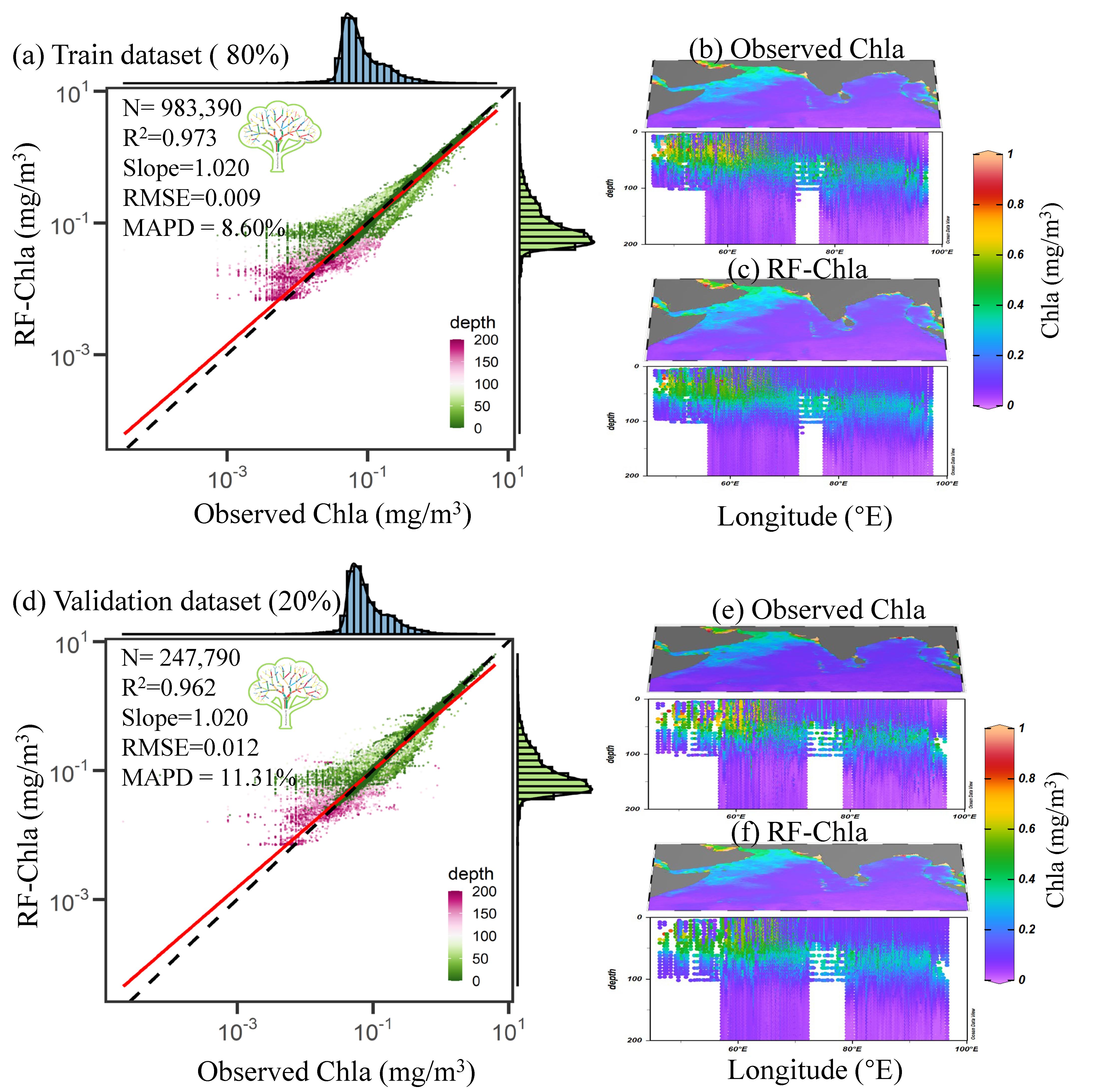
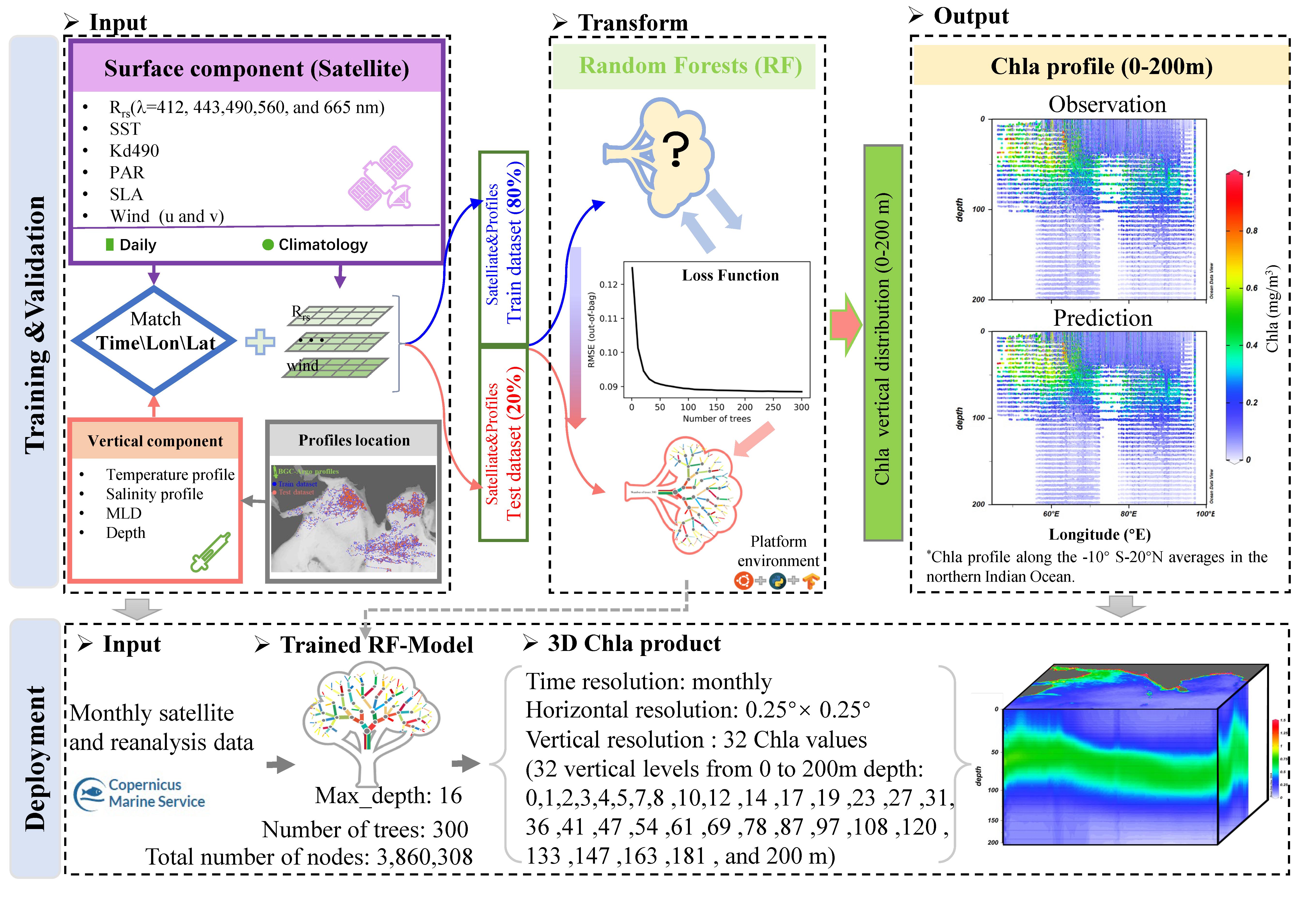
This study constructed a Random Forest (RF) model for the vertical distribution of Chla in the North Indian Ocean based on remote sensing and BGC-Argo observation data. The input variables of the RF model include: (1) surface information from remote sensing; (2) water column profile temperature and salinity information measured by BGC-Argo; (3) spatiotemporal information used to match the data, such as: day, longitude and latitude (Fig. 1). The training and validation datasets used by the RF model include 9,738 Chla and temperature-salinity profile files measured by BGC-Argo floats from 2011 to 2021, as well as satellite products of simultaneous observations. The results show that whether it is the training set or the validation set, RF-Chla has a very good correspondence with the observed values. RMSE is 0.009/0.012, MAPD is 8.60%/11.31%, and R2 is 0.973/0.962 respectively (Figure 2 ).
Figure 1. RF-Chla model construction process

Figure 2. RF-Chla model accuracy verification
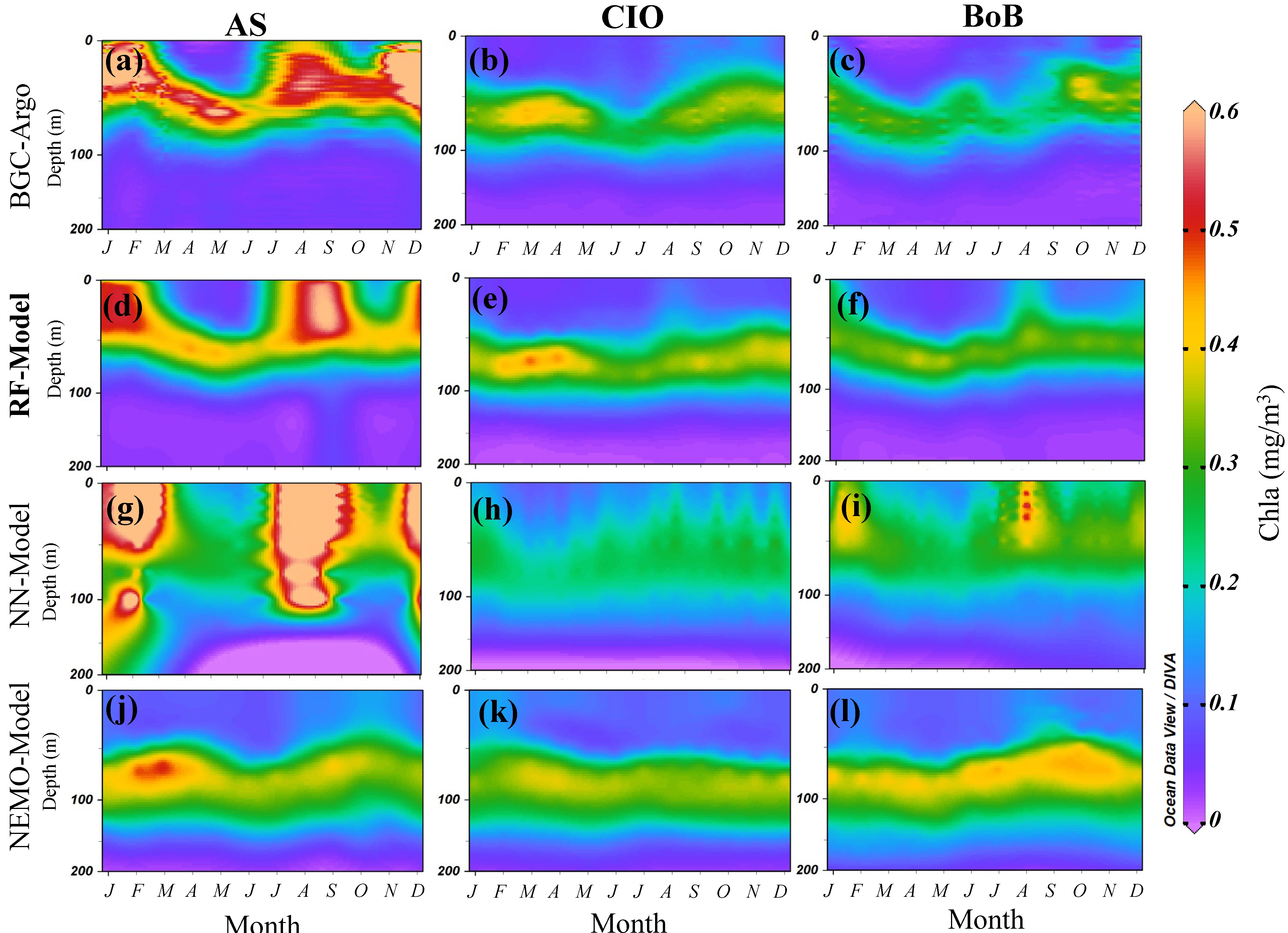
In addition, we compared the Chla vertical distribution characteristics obtained by the RF model with BGC-Argo data, the neural network product (NN-Model) and numerical model data (NEMO-Model) released by the ESA Copernicus Data Center . As shown in Figure 3, it can be found that the RF model results are most consistent with the BGC-Argo data, and the subsurface phytoplankton maximum layer and the surface phytoplankton outbreak in the Arabian Sea can be well characterized. However, NN-Model has relatively large overestimation or underestimation, and NEMO-Model does not simulate the outbreak of phytoplankton in the surface layer of the Arabian Sea at all.
Figure 3 Vertical distribution diagram of chlorophyll a concentration in different models
Therefore, the RF model we established can effectively obtain the three-dimensional structure of Chla in the North Indian Ocean with high vertical resolution. This will help us more accurately assess phytoplankton productivity and carbon fluxes in the North Indian Ocean. In addition, the RF model can also be used to develop long-term series of three-dimensional Chl a distribution products to help us understand more about the impact of climate change on marine ecosystems.
Citation: Hu Qiwei, Chen Xiaoyan, Bai Yan, He Xianqiang, Li Teng, and Pan Delu. (2022) Reconstruction of 3-D Ocean Chlorophyll a Structure in the Northern Indian Ocean Using Satellite and BGC-Argo Data. IEEE Transactions on Geoscience and Remote Sensing.


