Chlorophyll a concentration (chlor_a): chlor_a is an essential mediator in the process of marine primary production. This dataset is provided by NASA, and the updated dataset R2022 version is calculated using the blend algorithm of O'Reilly OCx band ratio and Hu color index CI algorithm, with units in mg m-3. Total absorption at 443nm (a443): The total absorption coefficient at 443nm in seawater is one of the main parameters affecting the distribution of the aquatic light field and is an inherent optical property of water. This dataset is obtained using the Generalized Inherent Optical Properties (GIOP) model, with units in m-1.
Total backscattering at 443nm (bb443): The total backscattering coefficient at 443nm in seawater is one of the main parameters affecting the distribution of the aquatic light field and is an inherent optical property of water. This dataset is obtained using the Generalized Inherent Optical Properties (GIOP) model, with units in m-1.
Diffuse attenuation coefficient for downwelling irradiance at 490 nm (Kd490): The diffuse attenuation coefficient at 490nm is related to the inherent optical properties of water and the underwater light field, and is widely used to describe the penetrating ability of light in ocean. This dataset is calculated based on empirical algorithms using measured Kd490 and remote sensing reflectance in the blue-green spectral bands, with units in m-1.
Sea Surface Temperature (SST) at 11 µm: This dataset represents the sea surface temperature measured by an infrared radiometer. The SST algorithm uses an improved nonlinear sea surface temperature algorithm (NLSST) derived from empirical coefficients obtained through in-situ and satellite measurements. The algorithm is suitable for both daytime and nighttime observations, with units in ℃.
Nighttime Sea Surface Temperature (SST4) at 4 µm: The nighttime ocean surface temperature is calculated using shortwave infrared near 4 micrometers, which is more sensitive to changes in sea surface temperature. MODIS is the only sensor capable of deriving ocean surface temperature from the shortwave infrared window. The algorithm for SST4 is detailed in Kilpatrick et al. (2015), with units in ℃.
Photosynthetically Available Radiation (PAR): PAR is commonly defined as the energy flux of solar radiation in the 400-700nm wavelength range and is an important input parameter for calculating marine primary productivity, with units in Einstein m-2 d-1. Detailed information about the PAR algorithm for this dataset can be found in the white paper "Algorithm to estimate PAR from SeaWiFS data Version 1.2 - Documentation" by Frouin, Franz, and Wang.
Particulate Inorganic Carbon (PIC): PIC is an important component in the study of ocean carbon cycling. This dataset utilizes a method combining 2-band and 3-band algorithms to calculate PIC, utilizing normalized water-leaving radiance at 443nm and 547nm bands, as well as atmospheric apparent reflectance at 667nm, 748nm, and 869nm, with units in mol m-3.
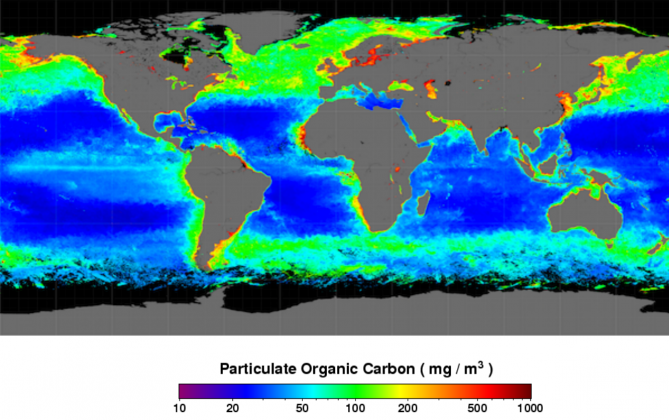
Particulate Organic Carbon (POC): POC is closely related to the ocean biological pump and is a crucial part of ocean carbon cycling research. This dataset employs an empirical relationship algorithm based on the ratio of particulate organic carbon measured in the field and remote sensing reflectance in the blue-green bands, with units in mol m-3.
Remote Sensing Reflectance at 412nm (Rrs412): The algorithm derives the upwelling spectral radiance below the ocean surface, normalized by downward solar irradiance, represented at the wavelength of 412nm as spectral "remote sensing" reflectance Rrs412, with units in sr-1. Remote sensing reflectance is a fundamental quantity derived from ocean color sensors, providing essential inputs for many derivative product algorithms.
Remote Sensing Reflectance at 443nm (Rrs443): The algorithm derives the upwelling spectral radiance below the ocean surface, normalized by downward solar irradiance, represented at the wavelength of 443nm as spectral "remote sensing" reflectance Rrs443, with units in sr-1. Remote sensing reflectance is a fundamental quantity derived from ocean color sensors, providing essential inputs for many derivative product algorithms.
Remote Sensing Reflectance at 469nm (Rrs469): The algorithm derives the upwelling spectral radiance below the ocean surface, normalized by downward solar irradiance, represented at the wavelength of 469nm as spectral "remote sensing" reflectance Rrs469, with units in sr-1. Remote sensing reflectance is a fundamental quantity derived from ocean color sensors, providing essential inputs for many derivative product algorithms.
Remote Sensing Reflectance at 488nm (Rrs488): The algorithm derives the upwelling spectral radiance below the ocean surface, normalized by downward solar irradiance, represented at the wavelength of 488nm as spectral "remote sensing" reflectance Rrs488, with units in sr-1. Remote sensing reflectance is a fundamental quantity derived from ocean color sensors, providing essential inputs for many derivative product algorithms.
Remote Sensing Reflectance at 531nm (Rrs531): The algorithm derives the upwelling spectral radiance below the ocean surface, normalized by downward solar irradiance, represented at the wavelength of 531nm as spectral "remote sensing" reflectance Rrs531, with units in sr-1. Remote sensing reflectance is a fundamental quantity derived from ocean color sensors, providing essential inputs for many derivative product algorithms.
Remote Sensing Reflectance at 547nm (Rrs547): The algorithm derives the upwelling spectral radiance below the ocean surface, normalized by downward solar irradiance, represented at the wavelength of 547nm as spectral "remote sensing" reflectance Rrs547, with units in sr-1. Remote sensing reflectance is a fundamental quantity derived from ocean color sensors, providing essential inputs for many derivative product algorithms.
Remote Sensing Reflectance at 555nm (Rrs555): The algorithm derives the upwelling spectral radiance below the ocean surface, normalized by downward solar irradiance, represented at the wavelength of 555nm as spectral "remote sensing" reflectance Rrs555, with units in sr-1. Remote sensing reflectance is a fundamental quantity derived from ocean color sensors, providing essential inputs for many derivative product algorithms.
Remote Sensing Reflectance at 645nm (Rrs645): The algorithm derives the upwelling spectral radiance below the ocean surface, normalized by downward solar irradiance, represented at the wavelength of 645nm as spectral "remote sensing" reflectance Rrs645, with units in sr-1. Remote sensing reflectance is a fundamental quantity derived from ocean color sensors, providing essential inputs for many derivative product algorithms.
Remote Sensing Reflectance at 667nm (Rrs667): The algorithm derives the upwelling spectral radiance below the ocean surface, normalized by downward solar irradiance, represented at the wavelength of 667nm as spectral "remote sensing" reflectance Rrs667, with units in sr-1. Remote sensing reflectance is a fundamental quantity derived from ocean color sensors, providing essential inputs for many derivative product algorithms.
Remote Sensing Reflectance at 678nm (Rrs678): The algorithm derives the upwelling spectral radiance below the ocean surface, normalized by downward solar irradiance, represented at the wavelength of 678nm as spectral "remote sensing" reflectance Rrs678, with units in sr-1. Remote sensing reflectance is a fundamental quantity derived from ocean color sensors, providing essential inputs for many derivative product algorithms.
unfold